

At its core, sonar software is the brain that lets us "see" with sound underwater. It takes invisible sound waves and turns them into detailed, visual maps of the sub-sea world. Think of it like a bat navigating in total darkness—it's the same principle of echolocation, just applied to everything from charting the ocean floor to finding submerged objects.
How Sonar Software Sees with Sound
Imagine you're in a pitch-black room. To get your bearings, you might clap your hands and listen for the echo to figure out where the walls are. Sonar software does the exact same thing, but with incredible speed and precision in the complex, murky depths of the water.
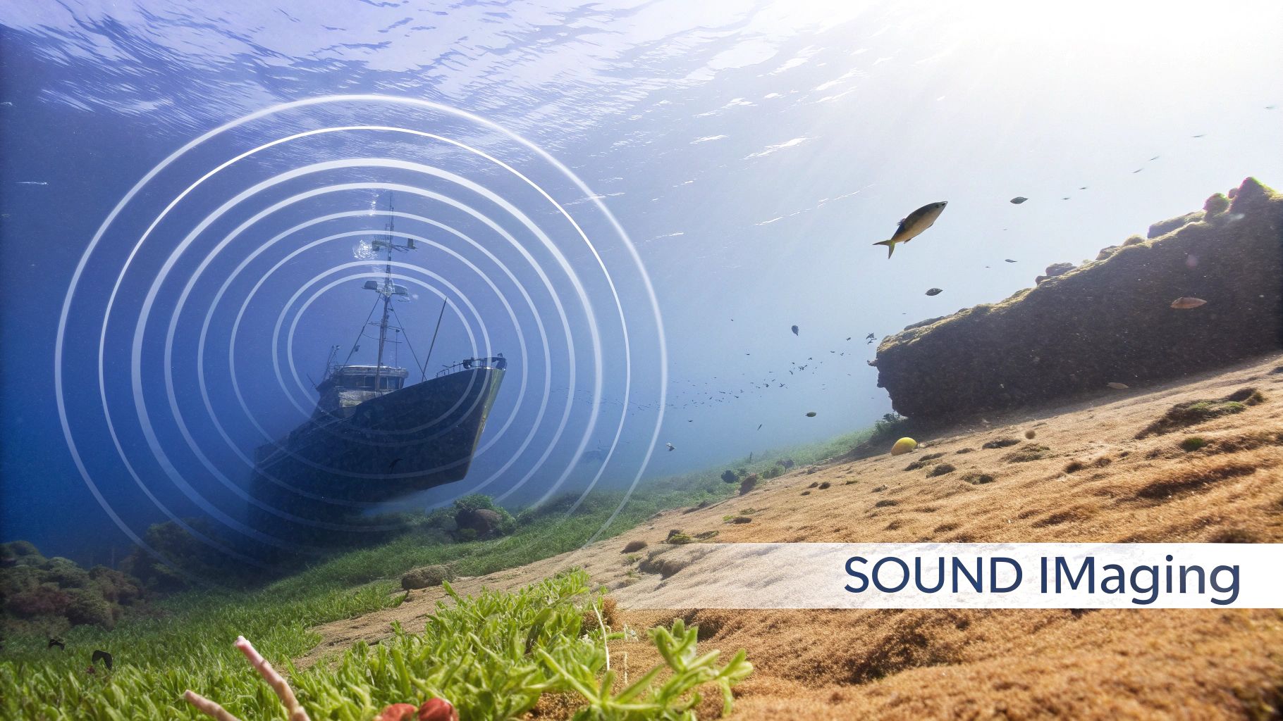
The whole system is built on a simple idea captured by its name: SOund Navigation And Ranging (SONAR). It all starts when the software tells a piece of hardware, the transducer, to send out a pulse of sound. This is famously known as a "ping." That sound wave travels through the water until it hits something—a shipwreck, a school of fish, or the seabed itself.
The Echo and Return Journey
Once that sound wave strikes an object, it bounces back toward the source, creating an echo. The transducer, which is now listening intently like a sensitive microphone, picks up this returning signal. This is where the magic happens.
The software meticulously measures the time it took for the ping to travel to the object and return. Since we know the speed of sound in water (roughly 1,500 meters per second, though it can vary), a quick calculation reveals the object's exact distance. A short return time means something is close; a longer one means it's farther away.
But it goes deeper than just distance. By analyzing the strength and frequency of the echo, the software can figure out an object's size, shape, and even what it's made of. A hard, rocky seabed sends back a strong, sharp echo, while a soft, muddy bottom returns a much weaker, more muffled one.
This is the fundamental loop of sonar in action—transmit, receive, and analyze.
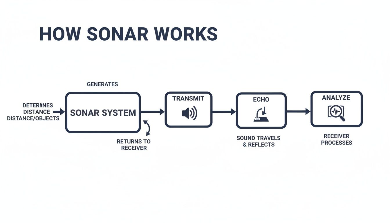
As the flowchart shows, it's a constant process. A controlled sound pulse is sent out, it reflects off whatever is down there, and the echo is captured and interpreted. By running this loop over and over, the software builds a continuous, dynamic picture of the unseen world beneath the waves.
Understanding Active vs Passive Sonar Systems
To really get a handle on modern sonar software, you first need to understand its two core "personalities": active and passive. Each one works with the underwater world in a fundamentally different way, and that difference makes them suited for very different jobs.
Think of it like the difference between shouting in a canyon and just quietly listening.
Active Sonar: The Speaker
Active sonar is the one that "shouts." It sends out a deliberate pulse of sound—the famous "ping"—into the water. It then goes quiet and listens for that sound to hit something and bounce back as an echo.
By measuring how long it takes for the echo to return and the direction it comes from, the software can calculate an object's range, bearing, and even get a sense of its size and shape. This makes it incredibly good at creating detailed maps of the seabed or finding specific objects that aren’t making any noise themselves, like a shipwreck or a pipeline.
Because it creates its own sound, active sonar doesn't need the target to cooperate. This is its greatest strength. It can find a silent, stationary container on the seafloor just as easily as it can track a moving submersible. It's the go-to choice for any task that demands high-precision mapping.
The global sonar market shows just how dominant this approach is. Active sonar systems held the largest market share at 50% in 2021, a segment valued at USD 3,059.0 million. Industry research shows this trend continuing, highlighting its vital role in defense, commercial shipping, and underwater exploration.
Passive Sonar: The Listener
In total contrast, passive sonar is the silent listener. It never makes a sound of its own. Instead, its job is to detect sounds that are already out there in the water using highly sensitive underwater microphones called hydrophones.
This could be the low thrum of an engine from a distant ship, the distinct churning of a submarine's propeller, or even the calls of marine life like whales and dolphins.
The huge advantage here is stealth. Since it emits no energy, a passive sonar system is completely undetectable. This is what makes it indispensable for military surveillance and covert operations, where giving away your own position would be a catastrophic failure. It’s also essential for scientific research, allowing scientists to study marine animals in their natural habitat without scaring them off with artificial noise.
The core trade-off is clear: Active sonar gives you precise location data but announces your presence to everything in the area. Passive sonar gives you stealth and lets you gather intelligence on anything making noise, but it has a much harder time pinpointing an exact location or tracking a silent object.
To help clarify the differences, here’s a quick side-by-side comparison:
Active Sonar vs Passive Sonar
| Feature | Active Sonar | Passive Sonar |
|---|---|---|
| Operational Principle | Transmits a sound ("ping") and analyzes the returning echo. | Listens for sounds emitted by other sources in the environment. |
| Primary Advantage | Provides precise range, bearing, and speed of a target. | Undetectable (stealthy). Allows for covert monitoring. |
| Main Disadvantage | Reveals the user's position to anyone listening. | Cannot detect silent targets; range and bearing are less precise. |
| Common Applications | Seabed mapping, mine hunting, fish finding, obstacle avoidance. | Submarine detection, military surveillance, marine biology research. |
Ultimately, the choice between active and passive sonar software comes down to the mission. Are you trying to meticulously map a wreck, or are you trying to discreetly monitor ship traffic? Your answer determines whether you need to speak up or just listen in.
Decoding the Data from Modern Sonar Software
Raw sonar echoes are just a wall of noise. It’s the sonar software that acts as the translator, turning that chaotic underwater sound into something a human can actually understand and use.
Think of it like this: the software’s first job is to act like a world-class audio engineer. It uses complex signal processing algorithms to filter out all the background chatter—the rumble of a ship’s engine, the clicks and calls of marine life, even the hum of its own hardware. It strips away the noise to isolate the clean, crisp echo returning from a target.
Once it has that clean signal, the real magic begins. The software takes thousands of these individual data points and starts piecing them together to create tangible, visual outputs.
From Pings to Pictures
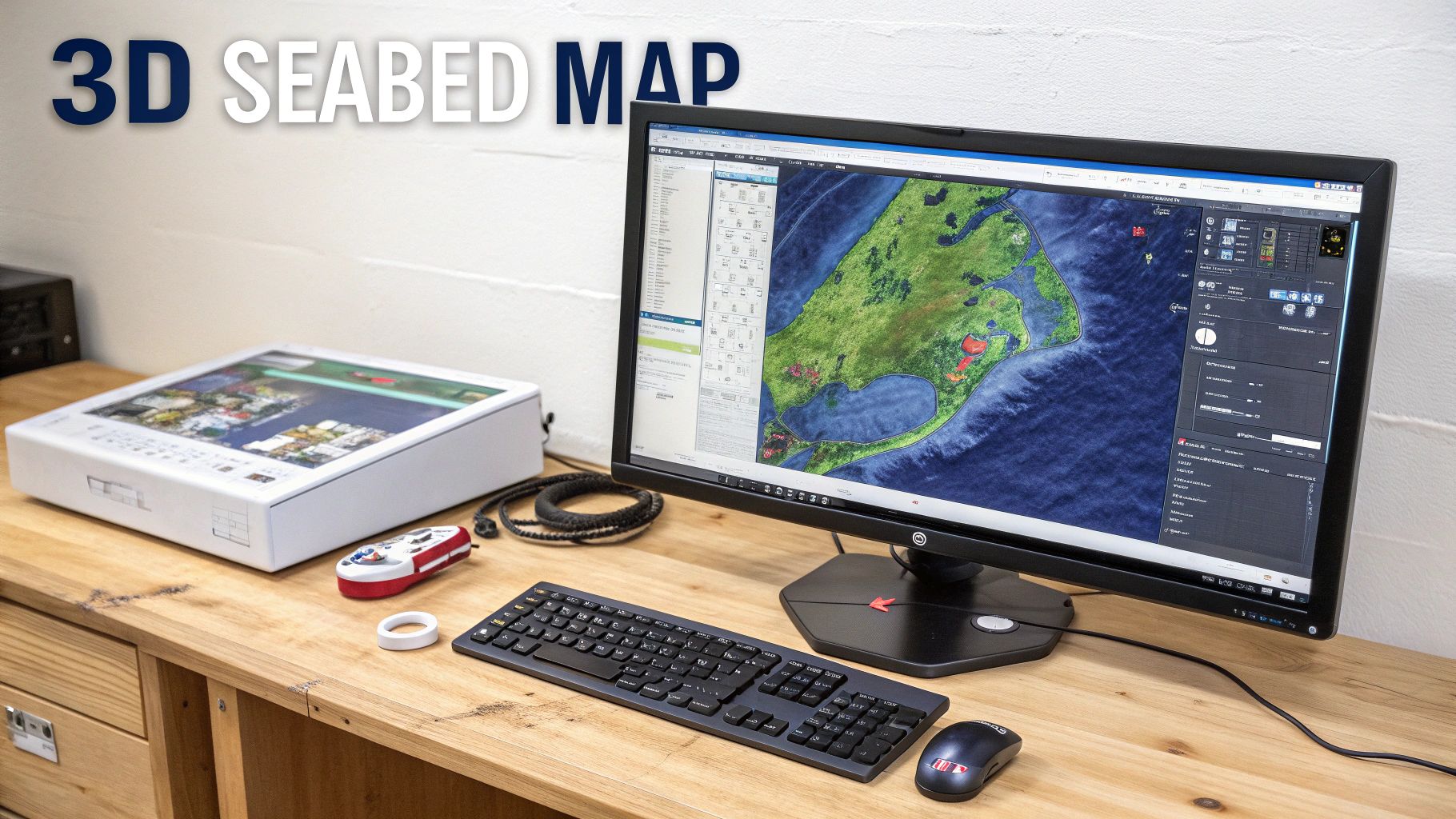
The most common and powerful output is a detailed map of the world beneath the waves. By stitching together countless echoes, the software paints a picture of the seafloor and anything resting on it. This isn't just a basic outline; it's a rich dataset that can be viewed in several ways.
- Bathymetry Maps: These are essentially 3D topographical maps of the seafloor. They reveal the hidden landscape of canyons, ridges, and underwater mountains with stunning precision.
- Side-Scan Mosaics: This output is more like a photograph. It produces a grayscale image of the seabed that’s incredibly good at showing texture and fine details. You can easily see the difference between a smooth, sandy bottom and a jagged, rocky reef.
- Water Column Data: This is a slice of everything happening between the surface and the seafloor. It visualizes schools of fish, clouds of plankton, underwater vegetation, and even thermoclines (distinct layers where water temperature changes).
The true power of modern sonar software is its ability to translate abstract sound waves into intuitive visual formats. It’s the bridge between raw data and human understanding, allowing an operator to see what would otherwise remain hidden beneath the waves.
AI-Powered Object Classification
Beyond just creating pictures, the most advanced systems are now using artificial intelligence to interpret what they're seeing. Instead of relying on a human operator to painstakingly identify every bump and anomaly on the seafloor, AI can do much of the heavy lifting automatically.
How? The software compares the unique acoustic signature of an object to a massive library of known profiles it has been trained on.
For instance, it can learn to distinguish the sharp, metallic echo of a shipwreck from the duller, more natural return of a large rock formation. This dramatically speeds up analysis time and boosts accuracy, which is a game-changer for large-scale surveys. As the role of AI, IoT, and Edge Computing continues to expand, this capability will only get smarter and more precise. In short, AI turns a simple mapping tool into an intelligent detection system.
These outputs provide the critical insights that drive maritime decisions. Whether it's a hydrographer charting safe shipping lanes, an archaeologist discovering a lost piece of history, or a security team monitoring a port, the data decoded by the software makes their work possible. Understanding how data interpretation drives business decisions is key, a concept we explore further in our guide on the importance of call analytics in communications.
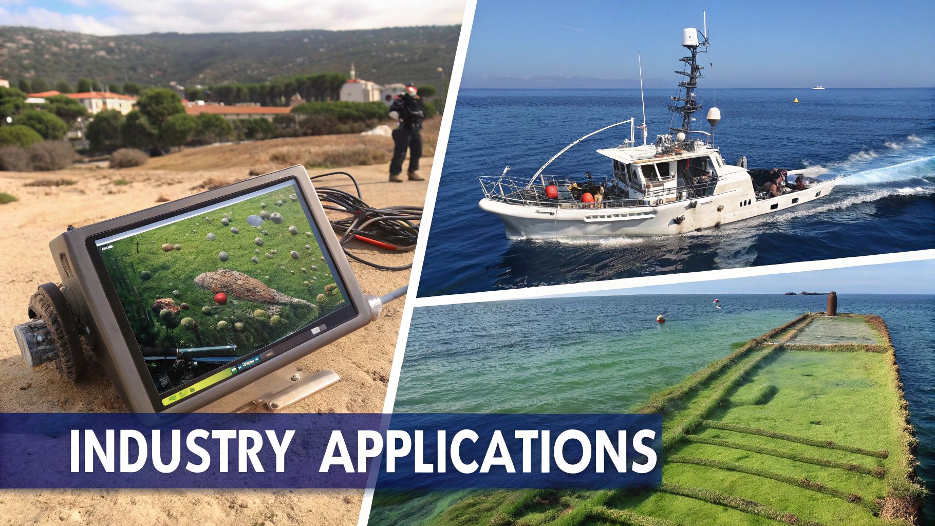
Sonar Technology in Action Across Industries
While the physics behind sonar is fascinating, its true power comes to life when you see it solving real-world problems. This technology is the underwater eyes for a huge range of critical operations, turning invisible sound waves into actionable intelligence that drives safety, discovery, and efficiency.
From guarding national borders to uncovering ancient shipwrecks, sonar brings clarity to the murky depths. Each application tells a story of a unique challenge met with an elegant technological solution, highlighting just how versatile this software can be.
Safeguarding Nations and Harbors
Defense is arguably the most demanding—and advanced—arena for sonar. The technology is an absolute cornerstone of maritime security, used for everything from monitoring strategic waterways to hunting for underwater threats. Passive sonar systems are mission-critical for navies, allowing them to detect and track hostile submarines without giving away their own position.
At the same time, active sonar is indispensable for dangerous jobs like mine countermeasures, where it meticulously maps the seabed to find and neutralize hidden explosives. It's also used to secure harbors and critical infrastructure from underwater intruders. This dominance is clear in market data, where defense applications command the lion's share of R&D and investment. In fact, the defense segment held 65.95% of the sonar systems market in 2026, a figure driven by the growing need for sophisticated underwater surveillance. You can dig into more stats on the sonar system market share on Fortunebusinessinsights.com.
By providing a clear, real-time picture of the subsurface environment, sonar software gives defense forces a decisive strategic advantage, turning the opaque depths from a liability into a monitored battlespace.
Advancing Marine Archaeology and Science
Beyond the military, sonar software has become a revolutionary tool for explorers and scientists. For marine archaeologists, it has unlocked chapters of history that were once lost to the sea forever. High-frequency side-scan sonar can produce images of the seabed so clear they look almost like photographs, revealing the unmistakable outlines of long-lost vessels.
This technology allows research teams to identify, map, and study historical sites without ever disturbing them, preserving our fragile underwater heritage. Sonar was instrumental in finding famous wrecks like the Titanic and, more recently, Shackleton's Endurance, offering priceless insights into maritime history.
In marine science, sonar is used to:
- Map ocean floors to understand geological processes like volcanic activity and shifting tectonic plates.
- Monitor marine habitats like coral reefs and seagrass beds to track their health and measure the impact of climate change.
- Study marine life by tracking fish populations, observing whale migration patterns, and exploring mysterious deep-sea ecosystems.
Boosting Commercial Fishing and Resource Exploration
In the commercial world, sonar is a fundamental tool for both efficiency and sustainability. For the fishing industry, modern fish-finding sonar does far more than just spot fish. It can help differentiate between species, estimate the size of a school, and even visualize its behavior in real time.
This detailed intelligence helps crews make smarter decisions on the water. It reduces fuel consumption and, just as importantly, minimizes bycatch—the accidental capture of non-target species. By targeting specific schools with precision, fishing operations become more profitable and sustainable.
Likewise, in the energy sector, sonar software is used to survey the seabed for oil and gas deposits or to scout the best locations for laying underwater pipelines and cables. It provides the foundational data needed for massive engineering projects, ensuring infrastructure is placed safely and with minimal environmental impact.
How to Choose the Right Sonar Software Solution
Picking the right sonar software isn't just a simple purchase—it's a serious investment in your operational muscle. The perfect system for a deep-sea research vessel will be completely wrong for a harbor security team. Making the right call means getting brutally honest about your specific goals and the environment you’ll be operating in.
Think of it like choosing a camera. A wildlife photographer chasing a shot from a hundred yards away needs a massive telephoto lens. A portrait photographer, on the other hand, needs something that captures fine detail from a few feet away. Your sonar software has to be just as precisely matched to its job. A mismatch leads to wasted time, garbage data, and a hole in your budget.
Your first move is to outline exactly what you need to accomplish. This framework becomes your checklist, helping you slice through the marketing hype and focus on what actually matters for your work.
Define Your Operational Needs
Before you even think about comparing vendors or fancy features, you have to build a crystal-clear picture of what success looks like. Answering a few foundational questions will give you the criteria to judge any sonar software solution on its merits. Without that clarity, it’s far too easy to get distracted by impressive features you'll never actually use.
Start by digging into these key areas:
- Maximum Operational Depth: Just how deep are you going? Deeper operations demand lower-frequency systems whose signals travel farther. Shallow-water work, in contrast, can leverage high-frequency sonar for incredible detail.
- Required Image Resolution: What level of detail do you really need to see? Positively identifying a shipwreck requires much higher resolution than simply charting the bottom of a shipping channel.
- Target Size and Type: Are you hunting for large geological formations, small schools of fish, or man-made objects like underwater pipelines? The size and material of your target directly influence the ideal sonar frequency and the software processing needed to find it.
A common mistake is paying a premium for resolution that adds zero value to the actual mission. By defining your minimum acceptable data quality upfront, you stop yourself from buying capabilities that look great in a demo but don’t help you get the job done.
Evaluate Hardware and System Integration
Your sonar software doesn't work in a vacuum; it’s part of a much larger ecosystem of hardware. Its ability to play nicely with your existing (or planned) equipment is completely non-negotiable. Poor integration can cripple even the most powerful software, leading to data dropouts, bogus positioning, and endless troubleshooting headaches.
Drill down into these compatibility points:
- Transducer Compatibility: The software must be fully compatible with your transducer—the physical device that sends out and listens for the sound pulses. No exceptions.
- Navigation System Integration: How well does it mesh with your GPS and other positioning systems? Accurate location tagging is the backbone of any usable map or target tracking effort.
- Data Export Formats: Can the software export data in formats that your other analysis tools can actually read? Think GIS platforms, CAD software, or any other part of your workflow.
For the recreational crowd, sonar tech is often baked into integrated units. You can see how hardware and software are bundled together in the best fish finder GPS combos to get a feel for how it works in a consumer context.
In the end, a thorough evaluation of these factors will point you toward a solution that delivers rock-solid performance and a genuine return on your investment.
Integrating Sonar into Your Operational Workflow
A powerful sonar software system is only as good as its connection to your daily operations. Getting real value means deeply weaving this technology into your workflow, not just turning the equipment on. It’s a thoughtful process of aligning both the physical hardware and the software configuration so that the data you collect actually drives decisions.
It all starts with the hardware. The transducer—the part that sends and receives the sound pulses—has to be in the right spot. Get this wrong, and you’ll end up with "blind spots" or distorted readings from hull turbulence. At the same time, you need a rock-solid network connection to get massive data files from the field back to your analysis center without corruption or lag.
Aligning Software with Your Environment
Once the hardware is set, the real finesse comes in with the software calibration. The underwater world is constantly changing. Shifts in temperature, salinity, and pressure all mess with the speed of sound, and your software has to keep up.
The software must be calibrated to account for these specific environmental variables. Failing to do so is like trying to navigate with an uncalibrated compass; the resulting data will be inaccurate and unreliable, leading to flawed maps and incorrect target locations.
This crucial step is what turns raw, noisy signals into precise, trustworthy intelligence about distances and depths.
Creating a Seamless Data Pipeline
The end game here is to make sonar data a live, breathing part of your workflow, not just another static report you look at later. This means building automated pipelines that plug your sonar software directly into other critical business systems.
Think about what this looks like in the real world:
- Survey Data to Project Management: Imagine hydrographic survey data streaming directly into your project management tools. Your teams get instant, real-time updates on dredging progress or the status of a pipeline-laying operation. No more waiting for manual uploads.
- Security Alerts to Automated Responses: A surveillance sonar picks up an unauthorized diver in a restricted harbor. Instead of just a blip on a screen, it triggers an immediate, automated alert. This could instantly activate security cameras, ping personnel via text, and log the entire event—all without a human needing to lift a finger.
- Integrating AI for Smarter Operations: To take this even further, many teams are integrating advanced AI to manage the data flow. You can learn more about how a next-generation AI-powered customer support agent built for Sonar software can handle the initial alert triage and data logging, which frees up your human operators to focus only on the most critical responses.
When you embed sonar technology directly into your wider operational ecosystem, it stops being a simple monitoring tool and becomes an active player in boosting efficiency and security. This is the strategic approach that truly maximizes its value and guarantees a meaningful return on your investment.
Frequently Asked Questions About Sonar Software
What Is the Difference Between Sonar and Radar?
The easiest way to think about it is to consider the environment. Radar relies on radio waves, which are fantastic for traveling through the air but die out almost immediately in water. Sonar is the exact opposite.
Sonar software is built around sound waves, which travel incredibly well through water but are useless in the air. This is why radar is the perfect choice for aviation and tracking ships on the surface, while sonar is the undisputed champion for everything happening beneath the waves, from mapping the ocean floor to tracking submarines.
Can Sonar Harm Marine Life?
That's a very real and serious concern, particularly when it comes to the high-intensity systems used by the military. Those powerful sound pulses can absolutely interfere with the way marine mammals like whales and dolphins communicate, navigate, and find food.
Because of this, there are quite a few regulations in place to minimize the impact. These rules often include restricting the use of powerful sonar in biologically sensitive areas and pushing for the development of new technologies that are less disruptive to the underwater ecosystem.
For a deeper look into the world of sonar software, check out our related articles.
From advanced communication tools to robust operational analytics, SnapDial can modernize your business communications. Visit https://snap-dial.com to learn more.